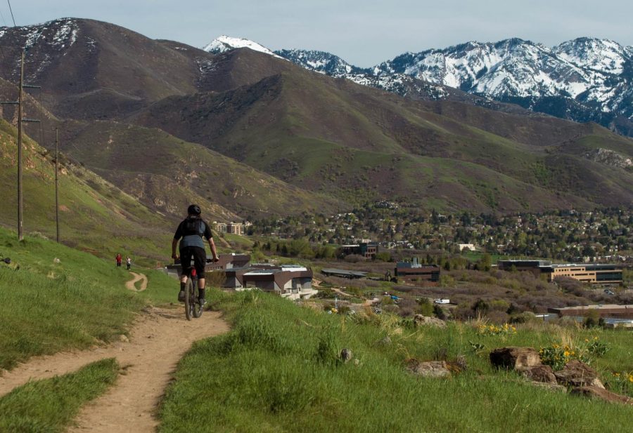
Limited by the elements, mountain bikers must wait until the landscape frees the familiar trails from the asperity of winter’s grasp to ride once again. Once the ice and slush melt away and the glorious dirt below is revealed again, a new season begins and bicycles become the most efficient way to see the land. Salt Lake City, quite literally surrounded in trail, is home to the Bonneville Shoreline trail, which holds a rich history of the city’s geographic origin. Follow along for an insight into how the advent of the trail shaped the sport of mountain biking in the city, along with the land itself.
While there are mountain bike trails south of Provo that run nearly year round, Salt Lake City truly blooms as a mountain biking hub once the snow melts in the late weeks of March and beginning of April. What once marked the waterfront of Lake Bonneville thousands of years ago is now known as the Bonneville Shoreline Trail. It provides world class single track riding along the east side of the city. As the skiing and snowboarding seasons start to wind down, mountain bikers start to get the itch for long single track days in the warm sun. When the Salt Lake City trails dry out, two-wheeled fun is on once again.
For those who may not take advantage of the opportunities that Utah’s winters have to offer, spring marks the end of a long season of patient waiting for the soil to break through the snow’s icy clutches, while the bike hangs in storage. After an entire season of obsessively cleaning drivetrains, replacing parts, and riding the stationary bike, the arrival of spring brings long-awaited feelings of satisfaction that cannot be replicated.
The Bonneville Shoreline Trail itself is also a vitally important piece of history, integral to what Salt Lake City has become over the last two hundred years. According to Encyclopedia Britannica, Lake Bonneville existed roughly 30,000 years ago and previously encompassed much of present-day Nevada, Idaho, and Utah, spanning over 200,000 square miles. The lake’s tributaries converged into a series of deltas around the Salt Lake City area that effectively created the canyons that many of us are accustomed to, including Emigration, Parley’s, and the Cottonwoods. These canyons flowed with water for many thousands of years, and eventually drew settlers to the area for the irrigable land surrounded by mostly dry climate. The canyons also deposited water to the surviving fragments of Lake Bonneville, only a fraction of its former size, and the saline Great Salt Lake and Lake Utah. As the water slowly drained away over thousands of years, layers in the mountainside became apparent. One of these prominent layers exists today on the east side of Salt Lake City, and is now known as the aforementioned Bonneville Shoreline Trail.
When Lake Bonneville began to slowly recede, there were still glaciers nestled into the Wasatch Mountains. As the water level of the lake and glaciers drained, shelves were formed on the mountainsides. These shelves, also known as benches, are especially apparent on the eastern side of Salt Lake City, where sections of certain neighborhoods and the University of Utah’s campus were built. The Bonneville Bench is where the Shoreline Trail lies. The trail also runs along the Wasatch fault.
The Wasatch fault is an active geological pattern that is constantly pushing the Wasatch peaks higher in elevation, and is a significant sort of pulsation to mountain ranges. It is only fitting that the Bonneville Shoreline Trail sits on such an important feature, as it is vital to city dwellers and college students as a nearby escape from reality to recreation.
The implications of Lake Bonneville’s past and its slow recession on the land are truly impressive. The geology of the lake and its flooding is what makes the Wasatch such an impressive mountain range, from its proximity to the desert to the seemingly endless snowfall in winter months. Aside from the incredible canyons, the land’s development also left us with the Great Salt Lake. Our city’s saline namesake is not only a massive tourist attraction, but is an important piece of Utah’s economy. The lake’s brines are used to produce a wide array of salt and sulfate products. From the remnants of the original lake, The Bonneville Salt Flats also boost the state’s economy as a massive destination for automobile enthusiasts, and the Great Salt Lake is responsible for the famous ‘lake effect’ that is proven to bring the Wasatch mountains such a great volume of powder snow. But for mountain bikers, the greatest offering from Lake Bonneville lies on the Shoreline trail.
The Bonneville Shoreline Trail stretches 100 miles along the ancient bench of Lake Bonneville from northern Utah in Cache county below the Idaho border, down through Salt Lake City and the Wasatch mountains to Spanish Fork. In the Salt Lake City area, the most popular range to mountain bike is from the Avenues near Ensign Peak, past Emigration Canyon, and eventually to Millcreek. The section just east of the city, from Ensign to Emigration, dries out quickly in the springtime due to its relatively low elevation and high sun exposure, which makes it possible to ride from March to November. This section is a long-awaited blessing for Salt Lake residents who are bike-minded, and becomes the first taste of springtime single track in the foothills due to proximity for residents. While a relatively low elevation trail along an eroding shoreline may sound flat and generally unimpressive, this trail is quite the contrary. BST carries an excellent balance between rambunctious descents and punchy technical climbs, which draws both Lycra-wearing cross country riders and all around trail riders alike. While novice riders may find the trail unforgiving, riders with some experience will find the uphill stints followed by fast, narrow single track to be quite addicting.

For those looking for more of an adrenaline rush, the Shoreline trail gives access to a handful of well known downhill-oriented trails in the Salt Lake area. Possibly the least well known is an extremely technical descent known as Terror Ridge that is accessible via Twin Peaks, connected to the section of BST just north of the University of Utah campus. Living up to its name, Terror Ridge is a relatively short and steep trail that is full of sharp rock spines and mandatory drops that require technical experience to navigate. The Shoreline trail is actually the only way to access this descent, as the ridge itself is too steep to ride up. Those who are familiar with this trail and the style of riding know that it is not about blasting downhill at maximum speed, but instead meticulously pinpointing the correct line without careening off the trail and over your handlebars. Terror Ridge is the most technical descent in this area, but this section of trail around the University of Utah campus gives access to a handful of classic descents.
Just about anyone who has taken an interest in mountain biking here in the Salt Lake valley has heard of the Bobsled downhill track. Known for a mix of terrain including steep and fast downhill, perfectly flowing berms and corners, and a famous jump section at the bottom, there is pretty much something for every discipline of rider. Additionally, there are multiple paths to get to the top of Bobsled, including the three mile stint up Dry Creek or the option to extend the route by starting on multiple trailheads along the Shoreline trail. There is even a way to shuttle near the top of the trail through the residential streets of the Avenues for riders looking to extend their time riding downhill. The top section of the trail is a natural water runoff with a drainage in the middle of the trail. This drainage can take a bit longer to dry out compared to the other sections, but provides a proper steep and narrow entrance to the trail and forces riders to stay on point from the start. The berms that follow are pure mountain biking bliss, the rhythm of riding the big banked walls back and forth is something all riders should experience. The trail concludes with a jump section that takes even the most experienced riders considerable time to master. Without getting into too much detail, old rusted cars can be jumped, as well as some hefty drops, but luckily there is an expert line with all of the jump features as well as a novice line with no mandatory jumps. This makes the trail approachable to all riders, and for that reason encounters with cross country riders are as common as run-ins with jump-savvy downhill riders.
Bonneville Shoreline is a jack of all trails, and a necessary stepping stone in the journey to becoming a mountain biker in the Salt Lake Valley. But the trail is full of all kinds of adventurers, from trail runners to friendly hikers to trail dogs. There are plans to expand the trail to nearly three times its current length, all the way from the Idaho border to the town of Nephi, a distance of two-hundred and eighty miles. There are a series of obstacles to this objective, quite literally, and funding is required to build bridges in order to link certain sections of the trail. To learn more about the Bonneville Shoreline’s proposed route, visit bonnevilleshorelinetrail.org where you can learn the route, register for trail work days, and donate to the expansion of the most substantial trail in the state. Momentous steps have already been taken to link trail sections, including the Parley’s Canyon Trail, which stretches fifteen miles of paved road and is a pleasure for road bikers and mountain bikers alike. To ensure more steps like this are taken, the Bonneville Shoreline Trail Coalition needs help from recreation enthusiasts of all forms.


